

A rare map of Hampton, hand sketched c.1830, was given to the museum in 2008 thanks to Susan Grant, librarian at the North Hampton Public Library and the library board of trustees. We are fairly certain that this is one of a kind and are in the process of narrowing down the exact date it was made.
Click here to view an enhanced high-res version of the map.
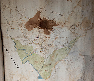
The image at right shows the map as it appears without any enhancements. As you can see, it is quite faint in many areas.
Ruth Perkins (wife of Judge John Perkins - former HHS president) gave the map to North Hampton in 1988. We are surmising that it was given to them because at first glance when the map is unrolled, it looks as if it is entitled “North Hampton.” Only upon closer examination do you realize that it is designating the boundary line of the neighboring town.
The staff of the Tuck Museum is currently investigating the map in detail, and are finding information that is filling in many gaps in Hampton's past. For instance the shape of the windmill (that was located near the area of Mill and today's High street) is almost identical to the windmill still on Nantucket. The area of Winnacunnet Road as it makes it's way around the bend past Landing Road to the beach is referred to as "Sandy Lane," and the grist mill still located at the end of High Street is labeled "clapboard mill."
The map is heavy paper attached to linen backing. Currently, it is in extremely fragile condition having considerable water damage and tearing along the edges. NH map expert, Gerry Miller, has scanned the map, and Rich Hureau has photographed it (the images on these pages), so we will be able to examine the details more carefully without adding any more strain to the map before conservation takes place.