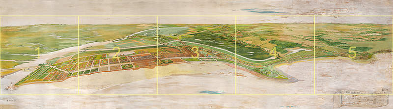
The above panoramic illustration of the seacoast area of Hampton (looking west from off-shore) shows proposed changes to the area made in the 1930s by the architectural firm of Warren H. Manning.
Click on a
numbered section of the above map to see a high-res version of that section. You will have the option of viewing a labeled or unlabeled version of that section.
Click
here to see a high-res view of the entire banner; use your browser
Back key to return here
Click
here to see a
labeled high-res view of the entire banner; use your browser
Back key to return here
Warren H. Manning - Banner - Prophecy for Hampton - Hampton N.H. 1930's
Are the marshlands of Hampton a wasteland, prime for economic development or
wetlands important to the health of the environment and the town?
For years this topic would be debated in the town and state with many proposals
put forward, but few adopted.
Warren H. Manning was a successful landscape architect who was hired by the
Hampton Beach Development Commission to draw up plans for the beautification,
restoration, and advancement of Hampton Beach. It was called the
Prophecy for Hampton.
Manning, his staff of artists, engineers and landscape gardeners came up with a
plan in 1933 that would change the beach for the better, they said, bringing in
more tourists, homeowners and generating wealth for the town and the state.
But in order to make things happen sand would have to shift, and marshes
covered to build canals, airports, playgrounds and house lots. Also, money would
need to be raised.
Hampton had just approved a large and expensive sewer project at the beach and
because of the town's lack of funds to make repairs after a series of destructive
storms the residents ordered the selectmen to accept the State's proposal to take
over the beachfront, transfer the land east of the Boulevard, build a protective
breakwater and acquire the Hampton River Bridge. All of this was done in the
early 1930's just as the Manning project came into view.
The State was anxious to develop the beach and supported any project that
would bring in more revenue. Airports to bring in more people, canals to bring in
boaters, and house lots with a view, bringing in wealthy owners.
Below is a newspaper article from November 17, 1932, describing the plans
Click here to view the original article; use your browser Back key to return here)
Recreational Plans For Beach
Development Are Shown To The
Commissioners Tuesday Night
Representatives of the Warren H. Manning Co. of Boston,
Landscape Designers and Regional Engineers, Brought
to Hampton Beach for the Approval of the
Development Commission, Tuesday Evening,
Plans for a New Hampton Beach
The development of Hampton River and the marshland has at last become a
reality in so far as the planning and drawing of plans is concerned. The
Warren H. Manning Co., of Boston, landscape designers and regional
engineers, engaged some time ago by the Hampton Beach Development
Commission has, after an exhaustive survey of Hampton and the Beach,
submitted tentative plans for the improvement of the Beach part of the
town.
The improvements planned spread over a period of years, each year
working to a goal for the completion of these ideals can be carried out
with very little added expense than the monies appropriated yearly for
highways, breakwater and sidewalks. By starting right with an object in
view great strides can be made in a short time toward the beautification
of the waste lands.
Mr. Manning, who has traveled from coast to coast planning and designing
parks and highways is very much impressed with the possibilities of the
future improvement of Hampton Beach. He sees nothing in the way of
making our present improved and waste lands, a typical Atlantic City,
bringing to Hampton great numbers of people of means and influence. The
plans as proposed add an area of 1,200 building lots, the river jetties
bringing back those acres lost at White Island by erosion and restoring
that part of the beach once so popular.
The plans show a new breakwater backed up by a twenty foot sidewalk, the
laying out of a new street parallel to Marsh Avenue, this street to be
bounded by a canal from the Hampton River Harbor reaching around to
Winnicummet [old way of spelling Winnacunnet] Road, which would provide
landing places for pleasure boats near the property of the summer
residents. A new road is proposed across the marsh as an outlet to
Lafayette Highway connecting the territory near the old landing, where
there is a great opportunity for the building of some fine estates, with
delightful background and scenery.
Also provision is made for the laying out of park areas and children�s
play grounds. A new music concourse, with seats for hundreds of people,
with a stage suitable for large bands, vaudeville or pageants, together
with the amplification of orthophonic concerts.
The planting of shrubs and bashes [sic] by the roadways would add to the
scenic beauty of the roadway hoped to be extended from Newburyport to
Portsmouth.
The final plans will be ready by the first of January in time to be
acted upon by state legislators at which time the public will be invited
to look over the completed drawings and hear the plans for this
development.
Representative Frank W. Emerson of Hampstead and a summer resident for
many years of Hampton Beach is president of the Development Commission
and James W. Tucker was chosen secretary. The directors are: George
Ashworth, Napoleon L. Demara of Lawrence, George Crocker, John A.
Janvrin, Stephen A. Lanen, Kenneth Ross, Frank E. Leavitt, Fred Lorenz
and Edward S. Seavey.
The development commission is working untiringly to bring these
improvements to Hampton with the aid of State and Federal Government and
bright prospects are held for the future.
I can only surmise why the Manning plan did not appear to find enough backing to
make the town take on the project. In the 1930's Hampton, New Hampshire, was
experiencing the effects of the stock market crash and the Great Depression. It
was probably due to these financial determents that the Manning plan never
came to fruition.
Banner and Tuck Museum Exhibit

The illustration/map that the Manning Landscape Company drew in 1933 is a 12' x 3.5' canvas banner with grommets across the top, designed to be displayed in public as publicity about the proposal. It hung in the Hampton Beach Fire Department meeting room for years and then was given to the Hampton Historical Society at some point. For years it was rolled up in the attic at the Tuck Museum. It is shown at left, partly unrolled. Note the poor condition, with water stains and warping, and also how rigid it is.
Click the image at left to see a larger view (use your browser
Back key to return here).
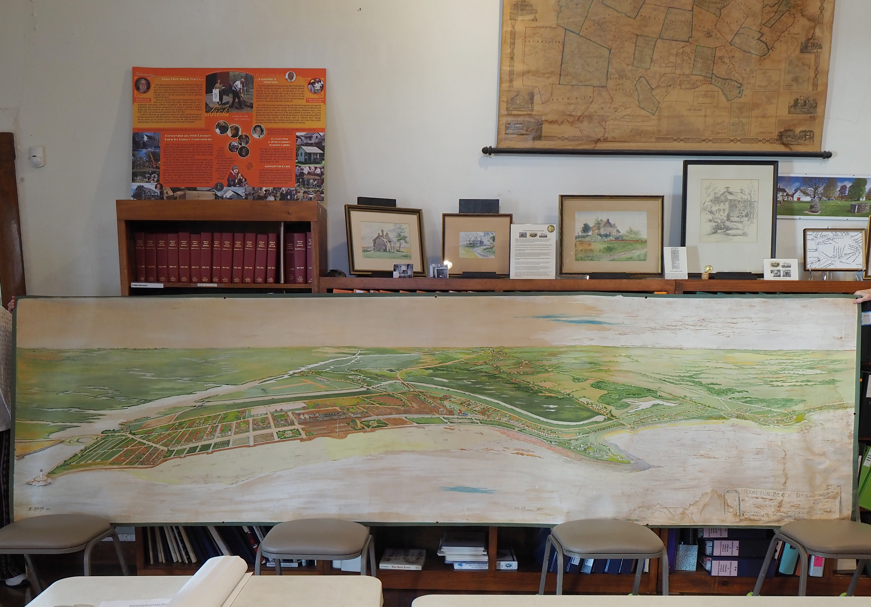
At right is another view of the original, fully unrolled and supported by 4 chairs. Again note the poor condition, with water stains and warping, especially in the upper left and lower right.
Click the image at right to see a larger view (use your browser
Back key to return here).
Director Betty Moore asked photographer Rich Hureau to photograph the banner in high resolution, and also attempt a digital restoration of the resulting image for future use (the original being badly damaged and in need of expensive physical restoration). The sectionized image at the top of this page shows the results at medium resolution (the final, full-resolution image is 22,610 x 6,247 pixels - 138MP!).
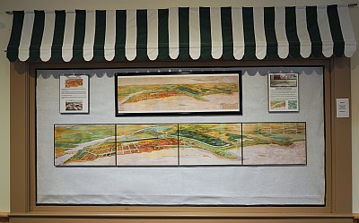
The restored image is part of an exhibit at the Tuck Museum (at right), which shows the full banner at quarter size on top, and then below it a half-size contiguous sectionalized print of the main land areas of it in striking detail.
Accompanying the museum exhibit is a looseleaf book assembled by HHS volunteer Karen Raynes containing more info the banner (for example, newspaper clippings from that time period), info about later attempts to modify the wetlands, plus info about Warren H. Manning, his life, and his other architectural projects.
1960s Plans (Not Implemented)
In the 1960's Marsh Reclamation plans would be proposed to assist the economy
of the town. Again, wasteland or wetland was echoed with the new plans.
Manning's plans were thought about again, and controversy continued.
Ruth Stimson voiced her convictions about the marsh: "Salt marshes are
unrivaled in their natural state for seacoast protection, as the vegetation is
resilient and emerges undamaged from storms that will sweep away houses and
stones in breakwaters. For these reasons, recreational, scientific, and economic,
conservation minded citizens and organizations are concerned and hope to take
measures to preserve the Hampton marshes."
There are 1342 acres of Hampton salt marsh. The largest in the Piscataqua
Estuary. This is a gift to the Hampton Community.
Karen Raynes, April, 2023